SURVEY TYPES : Boundary Survey / R-Plan
EXAMPLE SURVEY
SEE / CLICK BELOW
|
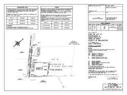
Boundary Survey
This type of survey produces what is known as a Reference Plan (R-Plan). The R-Plan becomes a publically accessible document at its corresponding Registry Office. Registry Offices contain a variety of publically available documents such as, Subdivision Plans, Deeds, Mortgages, Liens, etc. R-Plans accurately illustrate new or existing legal boundaries of parcels of land and may also show parcels, containing rights-of-way or easements (i.e.: in favour of utility companies or municipalities). Typically these plans do not show structures located on or adjacent to the property unless they directly affect or form the boundaries of the property. R-Plans are essential for:
| ||
